Bruce Stainsby's Blog: Muttering from the mo

Cultural overload. (October 2014)

January 25th, 2015

DSC01560

We left Samarkand early, it was a long drive to Bukhara and our driver wanted to stop at Shakhrisabz on the way.

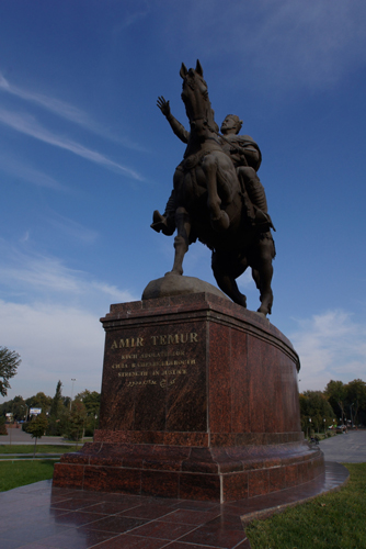
Shakhrisabz is the home of Amir Timur, the national hero of the Uzbeks. It is not hard to understand why he is so adored, especially by Islam Karimov. Timur ruled in the time after Ghenghis Kaan and although he was no softy he was benign compared to Khan, who devastated cities and massacred countless populations in his quest to control Central Asia.

Within Shakhrisabz is Amir Timur’s castle which currently stands at the end of a vast building site.

The entire town is being turned into a shrine in honour of the national hero and as a memorial to Karimov, the current prime minister.

This is yet another beautification program, initiated by Karimov that involves leveling vast areas of the old town and building boulevards and parks.

The resilient locals, displaced from their homes and businesses, carry on as usual. The market stretched along a raised dirt road, with construction on either side and heavy machinery racing from one end of the site to the other.

Just as we were about to leave it started to rain, then a dust storm came in from the surrounding desert.

All this was exacerbated by the dirt and dust from construction site.

We managed to see a few sites like the Blue Dome at the Dorut-Tilovat Complex and the local market area. However many of the old buildings were part of the reconstruction programme and off limits.

As we drove on towards Bukhara there was another downpour and it was literally raining dirt.

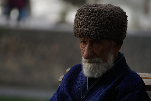
Sometimes a city is defined by headwear.

Bukhara has cloth caps and since we met our driver, who continually wore one, I have seen them on the men of the city.

The last time I encountered a community of cloth caps was in Pamplona, Spain in 2012.

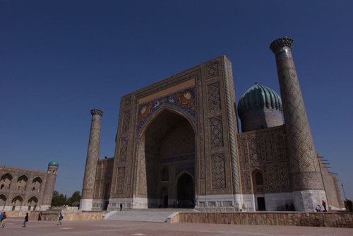
Before Islam there was Buddhism and fire worshiping Zoroastrianism, so there is a rich culture and history in Bukhara, which is believed to be 2,500 to 4,000 years old. The locals believe it’s the latter, while archeologists favour the former. It was the centre of the Silk Road and an important trading point between east and west.

Bukhara is an open air museum, with its historic centre, containing many mosques and madrassahs, listed as a UNESCO World heritage Site.

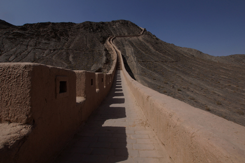
The city is surrounded by a 12km of wall containing 11 gates. The gates are named by the direction from which the caravans arrived into the city.

This is a small city compared to the others we have visited in Uzbekistan. It’s also one of the most tastefully reconstructed, with less of the glitz and a far more authentic feel. It’s easy to walk around the narrow streets and get lost in the back alleys.

Like most of these ancient cities, they are divided into distinctly different parts. With Bukhara the old part has charm while the new has vast parks and decaying Soviet era buildings.

The old part of the city is very compact and it’s easy to walk from one ancient edifice to the next. We spent an entire day doing just that.

The Arc and Registan Square, the Bolo-Hauz or Friday Mosque and then into the main market. This was a modern market, compared to some we had seen, but still had wonderful produce and interesting faces.

Adjacent to the market is part of the original city wall of mud bricks and straw.

We continued walking and exploring, visiting Ismoil Samoniy and Chashma Ayub Mausoleums, Kalon Minaret and Mosque and Mir-i-Arab and Kokaldosh Medressas. Kokaldosh is the largest one in Bukhara.

On the way we passed Magoki Attori, a Mosque that appears to be in a pit, as it has entrances on two levels. One is at the current ground level while the other is several meters lower. When it was excavated some years ago archeologists discovered that there was another temple below the current one. This was Buddhist, a religion that preceded Islam in Bukhara. It was then back to Lyabi-Hauz, the wonderful square that was near our hotel.

In the middle of all this we also went to Job’s Well, named after the Prophet from the Old Testament.

This is only a legend as the original Well of Job is in Jerusalem.

We crammed so much into the day that I have to check my snaps to actually follow what we did. Our guide, Dilafruz, was on a mission and wanted to get through as much as possible, as quickly as she could.

Our heads were spinning and we had cultural overload.

Bukhara is an oasis with many ponds that are interconnected. In ancient times the quality of water in these reservoirs was so poor that the average age of the Bukharise was only 39 years.

Apart from a number of Caravansaries in Bukhara there is also accommodation for Dervishes or travelling Islamic pilgrims. One such building is the Nodir Devon Begi that was built in 1620.

The Dervishes are best known in Turkey and Egypt where, in a religious fervor, they would spin and whirl.

Because Bukhara is on the Silk Road it’s also the centre of a well worn tourist track, best illustrated by the Coffee Gallery that serves an excellent cup of Segafredo.

After a hard day of sightseeing the Europeans gather to enjoy an espresso.

There were five trading domes built in Bukhara during the sixteenth and seventeenth century. Each one specialised in a particular range of merchandise. There are now only three left and their specialities are hats (many of the cloth cap variety), jewellery and money changing.

The last we visited on our final day as we were running short of Som.

The next day we were off again, our first stop being the tiny Chor-Minor Madrasa, built between 1806 and 1807. Only the entrance portal remains, with its four towers or minarets. Apparently these represent the builder’s four ‘beautiful’ daughters. Supposedly this rather small building is based on a much larger one in India.

Next was Ismail Somoniy Mausoleum, celebrating the sons of Somoniy, the founders of the Samanid Dynasty, who renounced Zoroastrianism and embraced Islam around 900 AD.

Another stop was Chor-Bakr Mausoleum built over the burial place of Abu-Bakr-Said, who died in 970 AD and was a descendant of the Prophet Muhammad.

We also visited some more contemporary sites like the Russian Summer Palace, with the old part being built in the 1860s and the new section in 1913. This had a diversity of styles, featuring both Uzbek and Tsarist Russian architecture.

Cotton and wheat are the staple crops of Uzbekistan. The harvesting of the cotton happens three times a year and as nothing is mechanised everyone needs to help.

The universities give students time off and everyone is expected to give up some time. Our guide, Dilafruz, still spends a few days each season bringing in the crop.

Late in the afternoon, after another exhausting day of sites, and over a couple of cups of coffee we watched the locals pass by, many on bicycles.

I couldn’t resist trying to capture a few on my camera.

Our last day in Bukhara was only our second full day off and we just went wandering. The tourists had been packed into their coaches and cars and were off visiting the sites, as we had done on previous days.

We felt we had the place to ourselves.

One of the bi-products of time off is that you can write a few postcards over a cup of coffee  You then have to find somewhere to post them and this took us into the new part of the city.

In the afternoon we went wandering around the back streets of the old city. I then had time to take photos of things that weren’t tourist sites.

Yet another benefit of time off.

Samarkand, the city of stone. (October 2014)

January 25th, 2015

DSC08978

Fazil, our guide and driver in Samarkand was a self proclaimed, ‘Light’ Muslim. He was tolerant of all religions and was completely against the extremist views of the radical few. In fact he felt that much of the Koran was being misinterpreted by these islamists for their own needs and not for the good of Islam.

During both the Russian and Soviet eras each region or main city was designated a manufacturing industry. This enterprise would then supposedly supply their given product to the the entire USSR. Tea packing was the domain of Samarkand.

The original factory, built in the 1860s in the days of the Russian Empire, is still there but only packs a fraction of its former output.

By having these main industrial centers, full employment was guaranteed by the Russians and then the Soviets.

When the Soviet Union collapsed most of these factories couldn’t compete in a free market, where the products were cheaper and of better quality.

We have seen the results of this throughout the former Soviet dominated Eastern European countries and now here in the Stans.

We had a brief afternoon walk around Samarkand, including the exterior of the Registan, as we would be seeing it in detail the next day.

This is another Central Asian city with the indelible stamp of Russia planted firmly on its landscape. This is especially evident in the apartment blocks, factories and the illustrated grave stones in the cemetery.

There is a very large statue of a seated Timo, just near the Registan, which is strange considering he preferred to be mounted on a horse, not a seat. Apparently this was due to his lame leg, as a result of yet another battle wound.

The name Samarkand means ‘City of Stone’

The entire city of Samarkand has been designated a UNESCO World Heritage site. It’s known as the ‘Rome’ of the east with a history going back over 2,700 years.

There are four distinctly different parts to Samarkand.

The Ancient City, that was built into hills by the side of the Zeravshan River. and devastated by Chinggis Khan (Genghis Khan)* in 1219 AD, when he killed 300,000 of its inhabitants.

Before that it was Alexander the Great’s turn in 329 BC.

Then there’s the Old City that was built to replace it. As most of those killed in the Ancient City were living underground, in homes dug out of the river bed, they were buried where they fell. It was therefore not appropriate to rebuild the city over the top of their graves. The city was then built inside the old walls.

There’s also the New City, that expanded from the old and was developed by the Russian Colonialists and later the Soviets.

Finally there’s the Modern City that came after the break up of the Soviet Union when Uzbekistan gained its independence.

Many of the buildings in the Old City have very small doors, this we discovered is because they are made from the wood of mulberry trees. These trees only have a certain amount of usable timber, hence the doors aren’t very high.

We also discovered that the swastika is used extensively in some of the mosques and madrasahs. Used here, this symbol represents the four elements of earth, water, air and fire. The swastika has been used by many faiths and first appeared in Neolithic times.

Fazil is a guide who thinks about the best time of the day to take photographs.

He has delivered us to places of interest when the sun is in the right spot. Unlike most, who get you there when everything is back lit.

There should be more guides like Fazil.

On our first full day in Samarkand we visited the Silk Road Monument. There seems to be one of these in every city we visited.

Then it was onto the monuments of religious importance, like Shakhi Zindi or Living King Ensemble, that was constructed between the 11th and 19th centuries. It is connected, by legend, to Kusam Abbas, the cousin of the prophet Muhammad, who is said to be buried there.

After that we visited the famous Registan. We had a sneak preview the previous night but this was a far more detailed investigation. This was the centre of the ancient city during the rule of Timur. It is a public square that is surrounded by three madrasahs or Islamic schools. Ulugh Beg Madrasah (1417-1420), Tilya-Kori Madrasah (1646-1660) and Sher-Dor Madrassah (1619-1636) These buildings are the epitome of Islamic architecture, vast yet elegant and adorned with beautiful tile work.

Our final stop in the afternoon was to the Amir Timur Mausoleum, Gur-e Amir or ‘Tomb of the King’ The construction of the mausoleum was begun in 1407 for Muhammad Sultan, Tamerlane’s heir apparent and beloved grandson. It later became the family crypt for the Timur Dynasty.

We had run out of Islamic sites in the city so we moved onto other faiths like the Russian Orthodox Alexey Cathedral built 1912 and the Polish Roman Catholic Church of St. John the Baptist.

Late in the afternoon we visited the old Jewish Quarter, a lively area with kids playing football in the street. and old men discussing whatever old men discuss.

We tried on a few occasions to see the Ancient City but a film crew had the road cordoned off. There were however a number of vintage cars and an old bus, full of extras, all part of the filming.

Corruption is everywhere in Uzbekistan.

Despite a government facade that suggests it’s frowned upon, it’s actually encouraged.

You can only get US Dollars, Swiss Francs or Euros when you use your MasterCard or Visa in a bank. You then have to go to another counter to change that currency to the Uzbek Som.

You therefore pay double transaction fees and get a poor rate of exchange to boot.

The Bell Boy at our hotel in Tashkent suggested that we were better off exchanging our US Dollars on the black market, rather than going to the bank. Of course he could give us a very competitive rate.

Fazil our guide negotiated a better entrance fee, at every site we visited. Where the money went, I have no idea. He also got us a great deal on exchanging our money.

The icing on the cake was when we went to see the light show at the Registan.

There were eight or so tourists there to see the lights, that were supposed to come on at 8pm every evening.

Suddenly one of the on-duty policemen came over and suggested that if we a paid him US$10, per person, he could get the lights turned on.

We never did see the Registan illuminated.

Our last full day in Samarkand was a welcome day off. This was the first full day to ourselves since leaving Australia. We found a cafe serving real coffee, not Nescafé and then had a wander around some of Samarkand’s parks and the main Boulevard. And, as usual, brides with their accompanying photographic entourage were everywhere.

Yet again we were invited to a wedding.

*Many names of places, people or sites are spelt differently. This depends on where you are, what translations have been made or what dictionary or encyclopedia is being used.

For instance Chinggis Khan or Genghis Khan, Madressa or Madrassah, Caravanserie or Caravansary.  

Often a person’s name will change according to where it is being used. Alexander the Great was also known as Alexander III of Macedonia, especially in countries where he had vanquished large parts of the ancient population. The same went for Emir Timur, who was also known as Tamerlane, Tamerlan (due to his lame leg) or just Timur the Great.

Alexander is Great in Christian countries while Timur is Great in Islamic ones.

Authoritarianism rules, and has done for centuries. (October 2014)

January 23rd, 2015

DSC08750

Uzbekistan, especially the capital Tashkent, appears to be much wealthier than Kyrgyzstan, our previous Stan.

The roads are better, there is manufacturing and a strong, if authoritarian, government.

And there is oil.

Kazakhstan also had oil, yet in both these countries there seems to be a shortage of it, well a shortage of petrol. There’s no lack of petrol stations, however the vast majority of them are closed.

The evidence of the authoritarian government was everywhere.

About an hour out of Fergana we were stopped at a military road block where cars were searched and all documents had to be presented.

This was yet another shemozzle.

Five lanes were clearly marked, yet everyone formed their own queue.

We had been told that there were five million in the Uzbekistan military and if these check points are anything to go by, I now understand. The one we passed was crawling with armed soldiers in full battle fatigues.

There is also a large police presence and drivers are routinely pulled over for a license check or for speeding.

I lost count how many times our driver’s radar detector went off.

Another bureaucratic nightmare was paying at a restaurant.

We hadn’t really celebrated our wedding anniversary properly, so this was the time.

It was relatively upmarket and the bill was more than we had been used to. This was definitely going to go on the Visa, as we would have needed a Brambles truck to deliver the cash in Uzbek Som.

When I slapped my card next to the bill, both the card and I were given a quizzical look by the waiter, he then rushed over to the cashier with the card.

The conversation then went something like this:

Cashier: “Sorry we can’t accept Visa, we have only been open for 12 months and don’t have the authority yet.”

Me: “We can pay in US Dollars if you like.”

Cashier: “I’m sorry we can’t except US Dollars, that’s illegal.”

Me: “Well what can we do?”

Cashier: “Just come back tomorrow with the cash in Som.”

The Uzbeks are both friendly, and very trusting.

Hitching a ride isn’t dead, as we have found out in all of The Stans so far. People of all ages just wave down a passing car, and if it’s going in the right direction, you get a lift.

The next morning our guide Maria, and driver Sharzot picked us up from the hotel. Our first task was to get the cash for the restaurant.

It was Sunday and the banks were closed but we did manage to find an ATM at the Intercontinental Hotel. All we could get out was US Dollars as the machine, not surprisingly, had run dry of Som. Fortunately there was also an exchange in the hotel so would convert our dollars into yet another truck load of Som.

Then if was on the road to do some sightseeing rather than banking.

There are many monuments, statues and buildings that have been instigated and unequivocally   attributed to Uzbekistan’s first, and to this point only, president, Islam Karimov.

Karimov’s legacy to Uzbekistan and to the world seems to be a number of building and renovation projects that have been ‘Inspired by his dream’

We visited many of these with Maria, like the Shahidlar Xotirasi Monument, dedicated to the many thousands who lost their life in one of Stalin’s many ethnic purges. Next was the Earthquake Monument, again dedicated to the victims of the devastation earthquake of 1966.

Included was the Museum of History of Timurids, The Dom Forum and the rather grand statue of Amur Timur.

Apparently President Karimov, apart from having a love of grand plans, also has a love affair with Amur Timur, the Uzbeks historical hero.

Timur, also known as Tamerlane or Timur the Lame (approx. 1320 to 1405) was an Islamic leader who conquered vast parts of South, Central and Western Asia. It is estimated that his battles resulted in the deaths of over 17 million people, about 5% of the world’s population at that time.

We then spent time in Independence Square where storks (not pelicans as incorrectly written in the Lonely Planet guide) adorn the gates to the park.

We had visited many of these sites the evening before, but it was good to get a locals point of view.

We also spent time in the old part of Tashkent and went to the Khast Imom, the official Muslim religious centre and the sprawling Chorsu Bazaar.

The produce here is as varied as the people who sell it.

Tashkent is a very green city with wide tree lined streets and expansive parks.

In 2010 President Karimov had all the trees chopped down in the park that is home to a statue of his hero Tamerlane. This was apparently so the people could get a better view of Temur on his steed.

This is a shame considering many of the trees in Tashkent were brought in by Russian soldiers during their occupation of Uzbekistan in the 19th century. These soldiers were instructed to bring two trees from their home region in Russia.

Our driver from the first day, Imar, became our guide for our trip to the mountains.

It was a very slow journey to the ski resort of Chimyoan as Imar had previous speeding violations and one more infringement would leave him without a license.

Not a good position for a ‘driver’ to be in.

Chimyoan was in a state of suspended animation. The summer season, with walking and mountain biking, was over, while the ski season was still a few weeks away.

The rattly old ski lift was still operating, so we took a ride to the top to get a better view. There was still some snow on the mountains but the rugged rock faces were the main attraction.

From the top of the ski lift we could see Charvak Reservoir, our next destination.

This man made lake is both a water catchment area, hydro electricity producer and summer resort for the people of Tashkent.

The reservoir was very low and not producing any where near its maximum output of hydro power.

On the way back to Tashkent we passed through the satellite city of Chirchiq. Hundreds of new homes were under construction, all identical but far better than the ones they are replacing.

Very early the next morning we were dropped off at the station to catch the fast train to Samarkand.

Imar insisted we needed at least 45 minutes to get through security. I certainly didn’t doubt him, given our previous experiences with Uzbekistan security.

We were through the checkpoint and into the train in under ten minutes.

That was the first pleasant surprise, the second was the train – it was a gleaming new Bullet Train. I had imagined shades of the Orient Express.

It may have looked like a Shinkansen but that’s where the similarity ended. I am sure the locomotive was capable of high speeds but the tracks were not.

The train rocked and shuddered its way to Samarkand. We were forced to abandon using our computers, for fear of them ending up on the floor of the train.

Nirvana for bureaucrats. (October 2014)

January 22nd, 2015

DSC02746

After exiting Kyrgyzstan and walking the 500m through no-man’s-land we had an interesting hour getting through the Uzbekistan border point.

First we had a doctor (I know he was a doctor because of his white coat) check our temperatures, this was due to the ebola outbreak in Central Africa. Then there was passport control, where we had to fill out a long and complicated form twice, as there were no photocopiers, or even carbon paper.

Then it was the customs officers time to go through every piece of our luggage, especially Thea’s.

They looked at every package of medication, then checked it on the internet. They took both our phones and laboriously went through photos and emails, looking for videos.

They also went through Thea’s camera and computer but for some reason didn’t bother about my, ever increasing number of cameras.

They were very pleasant about it all and we were spared the body search, that most of the other travellers were subjected to.

Once we arrived in Fergana the next hurdle was getting some local currency. There are no ATMs here so you have to find a bank and then use our card to withdraw cash.

We wanted 400,000 Som (about AU$200). They didn’t understand and gave us US$400. We then had to try and get that converted to local currency.

This took another half hour.

We only converted US$200, but as the exchange rate at the time was 2,372 Som for one US Dollar we had a ‘sack full’ of money. The largest denomination is a 1,000 Som note and we had withdrawn 474,290 Som.  We spent the rest of our time in Uzbekistan trying to find places to store the vast quantities of currnecy we were accumulating.

The joys of travel.

Once we were through with the red tape we had a long afternoon walk around Fergana.

The streets are wide, the buildings are mostly new and it’s remarkably quiet.

Everything is there for the people, except that there are so few of them. There was even a bizarre children’s playground, with strange cartoon character sculptures, but no kids to enjoy it.

Fergana is a very new city and the government is encouraging people to move there. So much so that they are building many new houses and apartments. The houses come complete with furniture and are sold for 15% of their market value, the buyer then has fifteen years to pay the rest.

MAN and Isuzu Trucks are made under license in Uzbekistan, as are Chrysler and Daewoo cars. Uzbeks only drive locally produced vehicles in an effort boost the local economy.

This proved to be the origin of all the Daewoos that were everywhere in Osh, Kyrgyzstan.

Our time in Fergana seemed brief, this was for two reasons.

Firstly our guide short changed us with a two hour jaunt around the city, instead of the full day tour we were expecting.

The second reason is that we became preoccupied with proof reading Hayden’s PhD thesis. This wasn’t a hassle as the hotel had a pleasant garden, next to the pool, where we found a spot in the sun.

Our truncated tour around Fergana included yet another tour of a silk factory. This one was at Margilon, situated just 18km from Fergana. It has been a traditional centre of silk weaving for over 2,000 years.

The silk workshops were housed in a number of old, rundown buildings. The weavers and spinners work away frantically, as soon as the tourist walk through the door.

The attraction of these workshops, apart from the craft involved, was the wonderful natural light that came streaming through the large dirty windows.

We had dinner in the hotel restaurant, which in itself wasn’t that exciting.

However what occurred over dinner was rather interesting.

It’s was low season in Fergana and the hotels were rather scarcely populated.

One particular table in the restaurant was set and then re-set several times. A variety of fruits, salads and strong alcohol was on display.

The hotel staff were obviously under pressure, as they spent more time on this empty table than they did on the occupied ones.

I assumed that there was a group of local heavyweights coming for a clandestine meeting.

My imagination was running away with me.

When this mysterious group finally arrived it turned out to be a mother, her son, their father and a group of some dubious friends.

I can only assume that they were important, as they came through the back door.

We will never know.

Greek nuts. (October 2014)

January 21st, 2015

DSC08421

The rain had stopped and a light mist hung over the sky for our drive from Bishkek to Arslanbob. It then lifted and rising up before us was the snow capped Fergana Range.

We drove through the Otmek and Ala-Bel Passes, both over 3,000m high. As we descended we negotiated our way through more herds of animals coming down to the winter pastures in the valley below.

It was a long day in the car as it’s over 600km from Bishkek to Arslanbob, where we were having a home stay with a local family.

We passed the giant Toktogal Reservoir on the way. This is a huge source of hydro power for Kyrgyzstan, yet with the dryer seasons the reservoir is low and it’s not producing the electricity it once did.

Arslanbob is home to the world’s largest walnut grove, producing over 1500 tonnes of walnuts per year. The harvest happens in mid-September and the entire township is involved.

These are naturally occurring forests that were supposedly known during the time of Alexander the Great. The walnut is sometimes known as the ‘Greek Nut’ after Alexander. It’s believed that he exported the Arslanbob nuts to Greece after his Central Asian campaigns.

In more recent times walnuts from this region were Kyrgyzstan’s first export to Europe.

The country and the people seem to be poorer than in the north with fewer cars and more donkeys.

Our home stay was in a small property in the middle of a walnut forest. The nuts were everywhere, lying on the floor drying or piled high in containers. They are such an important part of the local economy, that when the children go out to play in the forest, they are expected to gather nuts.

The next day, before we started our drive from Arslanbob to Osh we visited the Long and Twin Water Falls.

The trip to the Long Water Fall involved a 15 minute drive in yet another Lada Niva. This was a little hairier than our first Lada experience and involved some real off-road driving. We then had a 45 minute climb up a steep shaley slope. This water fall has an impressive drop of 80m however the best views were looking back down the valley to Arslanbob.

The Twin Water Fall has a drop of 23m and is easily accessible from the township, without the need of a rattly Lada and driver.

The drive to Osh was a much shorter road trip, of under 200km, compared to the previous day and a lot easier on our backs and bums over the bumpy roads.

In Kyrgyzstan most vehicles are second hand and brought in from Japan, Korea or Europe. They come in left or right hand drive – either is acceptable.

The vehicles are usually between three and nine years old. This way they avoid the excessive new vehicle tax and still have a good life ahead of them.

There are many varieties of vehicles imported, from budget to luxury. Each town seems to have a predominance of a few particular brands.

Osh had Hummers and the humble Woo (Daewoo). The Woo is even the car of choice for the Osh taxi fleet. Which is not that practical when you have two sacks of potatoes, a box of tomatoes, 20 litres of water and your wife to transport home from the market.

Seat belts are compulsory, but only in the front seat. As these are mainly late model vehicles, they are fitted with both front and rear seat belts. However for some reason the rear belts are tucked away out of site, unable to be used. I questioned Vitalli about this and he insisted that he didn’t have any, despite the fact that his were clearly visible.

One was actually holding the spare tyre in place.

On the way to Osh we stopped at the Uzgen Archaeological and Architectural Complex. The minaret and mausoleum waere built between the tenth and eleventh centuries. The mausoleum was built in three stages which is evident by the three distinctive sections of the building.

Osh is one of the oldest cities in Central Asia, with a history dating back over 3,000 years.

It’s situated in the Ferghana Valley, that spans both Kyrgyzstan and neighbouring Uzbekistan.

In the 8th century it rose to prominence as a silk production centre along the Silk Road.

There has been much civil unrest in the region between ethic Kyrgyz and Uzbeks. First in 1990 and more recently in 2010.

Our morning tour of Osh took in Sulaiman-Too or Solomon’s Throne, a rocky outcrop that rises up abruptly behind the city. It’s of great significance to Muslims as the Prophet Mohammed is believed to have prayed there.

Built into the mountain side is the Cave Museum. The exhibits aren’t remarkable but the museum is certainly unique. The whole area has been declared a UNESCO World Heritage Site.

Within the rocks around Solomon’s Throne are many small spiritual areas that, used correctly, will cure ailments, give long life and even make women fertile.

After lunch we went to Osh Market (Not to be mistaken with the Osh Bazaar we had visited in Bishkek) where the usual array of fruit and veg were on display. Again all the clothes and souvenirs were made in China.

The drive from Osh to Kozhokelen was an interesting one.

Firstly I had the feeling that our driver and guide had no idea where we were going, secondly, neither did we.

We later discovered that this was their first trip to the Pamir Alay Mountains and we were in the vanguard of travellers to this region.

We finally arrived at our home stay after nearly three hours of driving, much of it making good use of the Nissan Pathfinder’s 4X4 capabilities.

Vitali then decided that we needed to make a ‘beer run’ so that took another 50 minutes, retracing our steps back down the mountain to another village.

This really was a home stay, as the family had moved into another area of the house and we had the prized room next to the oven. This was fine with us as the temperature had plummeted.

Naturally the loo was outside and, for obvious reasons, a distance from the house.

It was definitely going to be a one loo stop night.

Home stays are a way that the locals can make few extra Som on the side, as these frontier destinations have little tourist infrastructure, such as guest houses or hotels.

The next morning we were off for a 6km trek to ‘The Waterfall’, stopping along the way to see The Blue Grotto. This cave had become a shrine, in honour of a local Muslim, who was said to have had magical powers. Hanging near the cave was the head of an Ibex or ‘Marco Polo’ as they are known, also dedicated to this gifted local.

The weather was cold and damp but the views were spectacular.

As we descended it actually started to snow. I was very glad that I had packed my woollen beanie and gloves.

Shipping containers seem to get a second, or even a third life in Kyrgyzstan, as they are used in many different ways. They are the main storage area in the markets and on building sites. I have even seen them integrated into buildings and also pulled apart and used as fencing.

The people, culture and landscape of Kazakhstan and Kyrgyzstan are very different, however through their common ties with Russia they are also similar.

Our next stop is Uzbekistan so it will be interesting to see the Soviet legacy there.

Sausages, eggs and politics for breakfast. (October 2014)

January 20th, 2015

DSC00824

We arrived into Bishkek, Kyrgyzstan, in the evening and our guide, Asel, suggested a place to eat not far from the hotel. It was a huge restaurant with a vibrant noisy atmosphere. A replay of the AFL Grand Final was in progress on a large plasma screen in the corner. I don’t think that the locals were all that interested

I must admit, neither were we.

Kyrgyzstan is much poorer than neighboring Kazakhstan. The big difference is that it doesn’t have oil. There is still a huge Russian influence and like most post Soviet era countries, any industry left with the Russians. Soviet made goods have been replaced by those from China – they are cheaper and not surprisingly, better quality.

The condition of the roads are the most obvious example of the lack of public money.

Kyrgyzstan has certainly suffered by the vacuum that was left after the collapse of the Soviet Union.

They are on to their third president since independence in 1990. The first two were thrown out of office, and the country, by popular uprisings. They ruled for themselves and not the people.

The architecture has a very Russian influence. This is understandable considering the Kyrgyz were originally nomads and the yurt was their only dwelling.

Vitali, our driver, was Russian speaking but unlike most Russians, he had a good sense of humour. He was a Major in the Russian Army but has now taken a pension. Asel was from the mountains and a native Kyrgystany. Together they made a great team, which was fortunate as they were with us for our entire time in Kyrgyzstan.

On the morning of our first full day we visited Osh Bazaar. This is the largest market in Bishkek and covers an enormous area with a huge variety of goods.

The meat section contains a bespoke sausage maker. Here the customer can have there own selection of horse meat cuts stuffed into horse intestines. Horse is a delicacy in Kyrgyzstan and sells at a premium.

In the afternoon we visited the National Historical Museum, where two of the three floors are devoted to the glory of Lennin and Marx. There are many heroic sculptures and ceiling murals featuring Russian achievements. However the third floor does have some reasonably good Kyrgyzstan nomadic relics.

The museum was built in 1984 and has a strange Russian Art Deco, come Modernist Style to its design.

The way this museum has been designed and decorated is its own exhibit.

We then drove to Ala-Archa Gorge and back, unfortunately it was shrouded in fog. This did give a rather surreal quality to the snaps.

The fog turned to rain and we scampered off the mountain but not before getting rather soaked.

Here we met a Spaniard who was riding his pushbike from Asia to Spain.

On our third day we drove from Bishkek to Cholpon-Ata. We had Kazakhstan on our left and the snow capped peaks of Küngey Alta-Too Range on our right.

Kyrgyzstan is still a rural country and we were constantly being stopped by roaming herds of sheep, goats, horses and cows that were blocking the road. They were being moved from their summer pastures in the mountains to the winter ones in the valley.

We also stopped to get a bucket of strawberries from a roadside vendor – the last of the summer fruit.

The village people of Kyrgyzstan still live by the traditional ways and arranged marriages are common. There are still cases of bride kidnappings and our guide Asel, a village girl herself, said she only visited her parents occasionally when she was at university as she was of kidnapping age.

On the way to Cholpon-Ata we had a side-trip to the ruins of the Minaret, Mosque and Mausoleum of the Balasaygn City centre. This was originally built in the the eleventh and twelfth centuries. All that remains is Burana Tower, this was rebuilt in the 1950s by the Russians. At the same site there are headstones from the six century depicting distinguished looking gentlemen holding a cup of wine. Plus a few petroglyphs featuring Ibex, the region’s wild goat.

We stopped off for lunch at a local café and had some of the strawberries.

Cholpon-Ata sits on the northern side Issyk-Kul, the world’s second largest alpine lake. Because it’s salty it never freezes.

For two months in summer it’s a popular resort spot for Russians, Kazakhs and the local Kyrgyz.

Apparently during the high season it’s packed with sun seekers, when we arrived it was eerily quiet.

North of the town, in a field of glacial boulders, we saw more Petroglyphs, these were more substantial than what we had seen earlier. Most were from the 8th century BC to the 1st century AD. The site was unfortunately marred by tagging.

Getting there was interesting as we drove up the old airport runway.

Late in the afternoon, as the sun was getting low we visited the very strange Cultural Centre or Rukh Ordo. This is defined as a museum and contains five identical buildings, that represent the world’s major religions. On their spires are the symbols of Islam, Buddhism, Judaism and two forms of Christianity – Roman and Orthodox.

The next morning we had an interesting discussion on the Ukraine over breakfast.

This was initiated by Asel, not by us.

With so much Russian history, culture and influence in the area it’s not surprising that their point of view is decidedly pro Russian.

But then we are influenced by Western ideologies and that’s where our opinions are formed. Being able to see both sides offers an insight into how we are all being manipulated.

Power and influence is the driving force behind these conflicts and that applies to the way both Putin and Obama formulate their propaganda.

After healthy portions of sausages, eggs, more strawberries and politics for breakfast we were on the road again.

The rain had returned for our drive to Grigorevskoe Gorge and there was no chance of getting a better view of Lake Issyk-Kul.

It was the same with the gorge, which was disappointing. It was a rugged mountainous pass, with a fast flowing river. Which would have been very picturesque, given better weather.

Something completely different. (September 2014)

January 19th, 2015

DSC00760

Almaty in Kazakhstan was a sudden change from what we were used to, after the behemoth that is China.

We were suddenly in a far more European influenced society, with a greater mix of Caucasian faces. There were sidewalk cafés, far fewer people and polite drivers, who weren’t constantly honking their horns. And in regard to road rules, the humble pedestrian wasn’t at the bottom of the food chain.

The alphabet was Cyrillic and there was a mixture of right and left hand drive vehicles – yet they drive on the right.

Even the beds were softer than in China, which in some cases had been like sleeping on the kitchen table.

Taxis seem to be few and far between resulting in many people, both old and young, hitch hiking.

The word Almaty means apple – the name comes from the very large apples that once grew in the Tian Shan Mountains that dominates the city skyline.

Getting our visas for Turkmenistan was a high priority, and an interesting experience. Our guide, Marina, filled out the forms, they were submitted, corrected and then we were sent off to the bank to pay US$110 for the visas.

Then it was back to the consulate to submit the forms with a bank receipt.

The next day we returned to collect our visas and were given a lecture about the do’s and don’ts of travelling in Turkmenistan.

This was going to be a challenging country.

Touring around Almaty with our guide Marina and George her father, who was also our driver, was more like taking a city tour with friends.

Firstly we went to the the Ascension or Zenkov Cathedral where there was a service being held in remembrance of the Cossacks. There were young and old men in Russian uniforms and those ridiculously large hats that I remember from old cold war movies.

Zenkov Cathedral, completed in 1907, is Russian Orthodox and adorned with onion domes in cream and white. It’s made of timber and reportedly the third largest wooden structure in the world. The leader being the Forté residential block in Melbourne’s Docklands.

Then for a complete contrast we visited the Almaty Central Mosque that was build in the Turkish style in 1999. With over 70% of Kazakhs being Muslim this mosque is large, impressive and very busy, especially on Fridays.

After we visited the major sites Marina took us to the urban areas and we popped into a local market, supermarket and a department store. Here she chatted about life and living in Almaty. Then we went into the burbs to see where the affluent residents of Almaty live.

I wanted a carabina to hold extra equipment on my camera bag and George, who was the ‘outdoors’ type knew exactly where to go.

Our last stop was a walk up to the TV tower, overlooking the city. It was a balmy afternoon and some exercise was welcome. It was also a great opportunity to view Almaty from a high vantage point.

The area around the TV tower contained a mini zoo, an amusement park and spectacular views of the city and the surrounding mountain peaks.

Sadly our time in Kazakhstan was too short as we were only there for two nights.

The road trip from Almaty to Bishkek, in Kyrgyzstan, was made in a Soviet era Lada Niva. It was pouring with rain and I was wishing that we were still in George’s Toyota 4WD.

Valentino, our driver for the trip to the Kyrgyzstan border, took us through some of the villages that were originally on the ancient Silk Road. These caravans could only travel about thirty kilometers per day, which was the distance between the villages. As each village was built on a river, water and provisions were readily available.

It was then onto the highway and across the steppe with the Tien Shan Mountains on our left.

Go west young man. (September 2014)

January 18th, 2015

DSC02673

In Turpan there are two time zones. Beijing time, for the tourists, trains and hotels. Then there’s local time, which is two hours behind Beijing time, and for everyone else. And because of the heat, there is also siesta time.

Turpan is in the Xinjiang Uygur Autonomous region and covers an area of 1.66 million square kilometers.  It’s also the second lowest spot on earth, next to the Dead Sea. There is a big Muslim influence and many of the road signs and shop fronts are in both Chinese and Sanskrit.

Being an oasis town it was also a major stopping point along the Northern Silk Road.

We arrived at the Turpan rail station at 6:30am where we were met by our guide Xaia, pronounced Shi, and were then driven 40km to Turpan city and our hotel. After a shower and a rest, we started the day’s activities.

First was Flaming Mountain, which gets its name from the red colour of the stone.

This is a very apt name, especially under the searing heat of the summer sun, when temperatures an reach into the high forties.

Next was the Bezeklik or Thousand Buddha Caves. These are the poor cousin of the Mogao Caves we had just visited at Jiayuguan. The caves had been both pillaged and desecrated by Europeans and the locals Muslims.

The German Albert Von Le Coq (1860-1930) repatriated many of the sculptures and painting to Berlin. He carved and hacked away over 360 kilograms of artifacts, wall-carvings, and precious icons. A lot of these artifacts were subsequently destroyed during WW2.

Next was a visit to Grape Valley, just 10 kilometers east of Turpan. It’s an 8km by 2km stretch of fertile land sandwiched between the Bogda Mountain on the north and Kurultag Mountain on the south.

Grapes and mulberries have been growing here for more than 2000 years. There is reportedly over a hundred varieties of grapes grown in this area. However only 10% is used for wine, the rest is eaten fresh or dried.

The vines grow almost horizontally on the trellises and ripen in the shade, rather than in the scorching  sun.

Drying houses cover the hillsides as dried grapes get a much higher price than fresh. A farmer may only get 5 Yuen for 1kg of fresh grapes, however 1kg of quality dried fruit could fetch him up to 100 Yuen.

The temperature was hotting up and Xaia suggested we had a break and resume our site seeing at 5pm, when the weather was cooler.

When I read in our itinerary that we were going to see an irrigation facility I thought that it would be some high-tech engineering extravaganza.

This was far from the truth.

The Karez or wells is an ancient irrigation scheme, started during the Han Dynasty (206BC – 220AD)

There are over 1,100 Karez covering 5500 km in the Turpan Drepressio, the longest is 50km while the shortest is 5km.

A Karez is created by digging wells down to the water table, near a village. This might initially be 2m deep, then more wells are dug at 10m intervals, always down to the water. Then the vertical shafts are joined by a horizontal tunnel at the water table. This tunnel is usually only 1.2m high.

This process continues until the water source is located.

All the work was done by hand and many lives were lost due to tunnel collapses or drowning, when the water level suddenly surged.

The last Karez was dug in 1973, after that the water ran out.

There is oil in the Turpan region and much of the ground water has been contaminated due to constant drilling and subsequent oil seepage.

The water is used for drinking and irrigation, with many of the vineyards being supplied by water from the Karez.

In the middle of October they bury all the vines in clay. This is to prevent them dying off in the winter, when the temperature drops down to minus 15 degrees over night.

Turpan is an area of extremes.

The Ancient City of Jaime, 10 kilometers west of Turpan, was a Buddhist city of 7,000 inhabitants. It was built over 2,400 years ago, then destroyed by the Muslims in the fourteenth century.

Built on an elevated island, with a river on either side, it was a natural fortification, measuring 1,700m by 300m.

As with many ancient fort cities the farmers would leave the city, to work the fields during the day, then return to safety of the fort at night.

Because of the intense heat in Turpan there was only one storey built above ground and two below.

There are temples, lookout towers, administration buildings, houses for the common people and a palace for the king.

It took over three hours to drive to Urumqi, then on to The Grand Canyon of Nanshan, our first stop on day two.

This is obviously a popular spot for wedding snaps as there were at least a dozen bridal groups being photographed.

There was a couple that seemed to be without a photographer and I was asked to take their photo.

The Grand Canyon of Nanshan is in fact a reservoir created by damming a mountain river. There were stunning mountain views from some angles, that’s if you avoided the walkways and obligatory tourist glitz.

This is a racially mixed area with a large population of Uyghur, a Muslim minority in China.

There have been some tensions between the Uyghur and the Chinese authorities recently and we were stopped on four occasions at police checkpoints.

We then drove back to Urumqi and spent an hour in the Grand Bazaar.

The Bazaar is not that grand, despite the fact it’s the largest bazaar in the world. It’s more like a huge department store with individual store holders selling a range of tourist style souvenirs. The place was rather quiet, so I guess the locals agree.

Urumqi, like Turpan is part of China’s western development plan.

In order to relieve the overcrowding in Eastern and Southern China the government is trying to entice people to move west. There are acres and acres of new apartment blocks being built in expectation of the exodus from the east. Road and rail links are also being built with a new Bullet train from Xi’an to Urumqi, due to be completed next year.

A year too late for my liking as the Bullet trains are a far better option than the overnight rattlers we had been on recently.

We had an evening off and decided to walk around the city. On our wanders we discovered a rather bohemian cafe that served cold beer and good pizza. We were a bit over rice, noodles and strange cuts of meat by this stage. There was a rather unusual sign, hanging out the front, that seemed to be making light of the authoritarian rule.

I hope that the officials are more open minded in the west.

Urumqi was our last stop in China and the weather had really warmed up. Despite that we were told to bring warm clothes for our trip to Heavenly Lake.

Many tourist attractions in China are run by private companies and you are compelled to use their transport and facilities.

Heavenly Lake was no exception.

The private companies have a monopoly and you pay every step of the way. We paid to park the car then paid to see the lake. The entry fee was 100 Yuen, 90 Yuen of that goes towards the 56km, round trip on the shuttle bus.

Private vehicles are prohibited for day trippers.

Politics aside, it’s a beautiful natural lake surrounded by soaring, snow capped, mountain peaks.

The Great Wall really is great. (September 2014)

January 17th, 2015

DSC07887

We arrived into Jiayuguan on the overnight train from Lanzhou, after another sleep deprived night.

We had been put on the slow train that stopped at every station. We later discovered that there was a train that left half an hour later than ours and arrived two and a half hours earlier.

Vickie, our guide, was there to meet us and after another quick breakfast of beef and noodles we were back into the site seeing.

Our first stop was the Jiayuguan Pass, or Fort, and the Great Wall Museum.

The weather was warmer and the tourists fewer.

There was a choice as to how you could see the fort, one was by ultralight – we chose to walk.

The fort is located at the western end of the Great Wall and is historically one of the main passes through the wall. It was built during the early Ming dynasty, sometime around the year 1372.

This part of Western China is in the Gobi Desert and has been designated as an expansion area. Soil has been moved here in order to grow trees along the roadsides. The water comes from natural springs that have their origins in the nearby mountain range of Qing.

For millennia Chinese dynasties have been trying to tame this harsh environment. When this particular part of the Great Wall was constructed soldier/farmers were brought here both to defend the frontier and feed the growing population.

With the protection that the Great Wall offered, the Silk Road expanded and the area around Jiayuguan became a melting pot of multiculturalism.

Not only goods were traded but so were ideas.

From the fort it was a short drive to the Overhanging Great Wall. This is another part of the wall that has been renovated and gives you a good idea just what an enormous feat of construction the Great Wall was.

As we discovered in the museum, there is more than one wall that makes up the Great Wall complex. Successive Chinese dynasties have added to it according to their defensive needs.

The Great Wall, stretching from Dunhuang in the west to beyond Beijing in the east, was built over thousands of years and is estimated to have been 21,196 km in length. Considering that the circumference of the equator is 40,075 km, it really is great.

In the afternoon we made the long drive to Dunhuang and really got a feeling for the surrounding desert environment. There were patches of fertile farmland interspersed amongst a flat barren landscape. Ever present were the high tension power lines stretching as far as we could see.

We also passed two of the largest wind farms I have ever seen. There weren’t hundreds of turbines, there were thousands.

The Chinese don’t do anything on a small scale. Even the toilet block at one of the motorway rest stations had more urinals and cubicles than you would find on the entire Hume Highway.

Strangely the car park was empty so I guess they are looking to the future.

Dunhuang is an oasis in the Gobi Desert producing fruit, vegetables and grapes. Like the rest of China, it’s a work in progress, with cranes dominating the skyline and construction at every turn.

The next morning we were off to the Dunhuang Yardang National Geopark, which is about 180km from Dunhuang.

The rock formations in the park were formed by water and wind erosion over a 700,000 year period. This is the largest park of its kind in China.

The temperature was warm but the air was still hazy, a byproduct of China’s industrialisation, even this far west.

We them went to another outcrop of the Great Wall. This one was made of straw and mud, yet was still standing after 2,000 years.

The day was to be spent driving around the Gobi Desert and, as we discovered from Vicky, there are many colours of the Gobi. These depend on the makeup of the soil, there’s black, white, yellow and red. And when it rains and the grass grows, there’s even a Green Gobi, however this doesn’t happen very often, as the average rainfall is only 24mm.

A visit to Yumen Pass and Yangguan Pass completed a long, warm and dusty day in the desert.

Both these passes were important gateways on the Silk Road, joining Central Asia with China.

Day three started with a visit to the Mogoa Caves, made a UNESCO World Heritage site in 1987. Before we went to the actual caves we had an introduction in the ‘Digital Caves’. This was a high-tech, audio video explanation of the cave’s origins.

There were two video presentations, one explaining the geological origins of the caves and the other showing the caves in detail. The last video was in a 360 degree theatre with high resolution graphics that recreated some of the main imagery contained within the caves.

The Mogoa Caves are also known as the Caves of the Thousand Buddhas and contain 492 temples carved out of the sides of a steep river bank.

It has documented over a thousand years of Buddhist history in art, painting and sculpture.

Situated close to Dunhuang, the Mogoa Caves were of religious and cultural significance to the Silk Road travellers. They were abandoned in the eleventh century, a result of the spring feeding the river drying up.

In 1907 a Hungarian-British archeologist, Sir Marc Aurel Stein, discovered the ‘Library Cave’. This cave contained a wealth of religious and historical documents.

In the tradition of archeologists before him, he cheated the locals and plundered the treasure.

More treasure hunters came from France, Russia, the US and Japan. Resulting in most of the library now being held in foreign capitals.

Our last stop for the afternoon was the Singing Sand Mountains and Crescent Spring.

Here giant sand dunes dwarf the natural crescent shaped oasis. There is a pagoda next to the spring that was built in the 1990s. It replaced an old Buddhist temple that was destroyed by the Red Guard during the Cultural Revolution.

The facilities at all of the tourist sites we have visited have been amazing. They aren’t there for Westerners but for the Chinese, who are avid travellers.

Another long day was coming to an end, so it was back into the van for a two hour bumpy ride to Liuyuan to catch an overnight train to Turpan.

Our travelling companions on this trip were Alfred and Annamaria from Switzerland.

Alfred, discovering we were Australian and believed that sharing a cold beer wouldn’t be out of the question.

We did manage to convince the catering staff to sell us two cans of local ale, unfortunately they were warm.

Warm beer seems to be the norm as we moved west in China.

Tibet or not Tibet. (September 2014)

January 15th, 2015

DSC07823

We took the overnight train from Xi’an to Lanzhou. This is a city with a history dating back 2,000 years and was a major stopping point on the Silk Road.

We arrived in Lanzhou at 6.30am and were met by Adreana. After a quick breakfast of beef, noodles and vegetables, we set off to see the sites of the city.

We were meant to do this on our second day in Lanzhou however the road rules had changed and our driver, having a vehicle with even number plates, wasn’t permitted into the city area on the day we arrived.

This is a very small city, by Chinese standards, only having 3.4 million people, yet there is enough congestion to warrant a subway system. It’s construction was now causing more disruption hence the banning of vehicles from the CBD on certain days.

Our first stop was to visit the White Pagoda Mountain.

After crossing over the Lanzhou Iron Bridge we had a steep climb up the mountain to the pagoda. Unfortunately the pagoda was being renovated, as Lanzhou was the host city for the forthcoming Golden Rooster and Hundred Flowers Film Festivals, so its famed ‘whiteness’ was in no shape to be photographed.

The views of the Yellow River from the top were worth the climb – a climb that was welcome exercise after a night confined to the train.

The Yellow River is indeed yellow, well a clay colored muddy yellow. It is regarded by many Chinese as the ‘Mother River’ because its yellow colour matches their skin.

On a siding next to the river, and harnessing its power, are the Lanzhou Water Wheels. These are two giant timber wheels that currently divert water to a mill-house, via an elevated aqueduct. They were originally used to irrigate farmland in the area. The waterwheel was originally invented by Duan Xu in the Ming Dynasty (1368-1644).

Until 1952 about 252 waterwheels stood along the Yellow River at Lanzhou.

Adjacent to the waterwheels were a group of river rafts, that use inflated sheep skins as the means of flotation. They are a popular attraction with the Chinese during the tourist season.

There was even an onsite puncture repair centre.

The Mother Statue of the Yellow River, constructed in 1986, was just down the road. It was over run by Chinese tourists having their photo taken in front of it.

The statue is of a mother and baby. It’s believed that the baby’s gender is hidden, so the viewer can chose what sex they want it to be, when they make a wish for the good fortune of their own children.

It was then into the car and off for a four hour drive to Xiahe. This drive would normally take a lot less time but it was raining, slowing the traffic down considerably.

Xiahe County is in the Gannan Tibetan Autonomous Prefecture and is part of what was formally known as Tibet, but is now well and truly in China.

After arriving in Xiahe and checking into our hotel we were off to meet a Tibetan family on the Sangke Grassland.

These semi nomadic Tibetan herdsmen have three locations to graze their cattle and move from place to place, according to the seasons.

It was the beginning of autumn and most of the herd had already moved to the winter grasslands.

The next morning we visited the Labrang Monastery. This is a huge complex with over 1,000 monks living and learning there. It’s not only a monastery but a university that has a number of faculties including medicine, philosophy and of course Buddhism.

Apparently there are over 108 monasteries in Tibet, Labrang being the largest. From the amount of cash, received from offerings, I saw the monks counting, it may well be Tibet’s primary industry.

It was interesting to note that most of the Tibetans use iPhones and not the more common Chinese Android devices. This is because Apple have cleverly included Tibetan in their language selection.

Something the Chinese refuse to do.

In the afternoon we had a long walk around Xiahe and another great coffee at Cafe Norden. The coffee was an unexpected highlight, given where we were.

Tibet, like most of China, is modernising and new buildings are popping up at a rapid rate. The small town of Xiahe was no exception, with indoor shopping malls being built adjacent to the main street. From what I could see these were very underused, with most shopkeepers preferring to remain on the main thoroughfare.

It was then back into the car for another long, wet drive back to Lanzhou.

When we arrived the traffic was chaotic. Again it was the turn of vehicles with even number plates and our driver only had permission to drop us off at the railway station for our trip to Jiayuguan.

I would hate to imagine what it would be like with both odds and evens on the road.