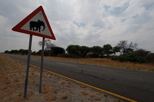
Day 1, November 11: Port Elizabeth to Tsitsikamma National Park.
The weather had certainly changed for the cooler as we commenced our trip west, from Port Elizabeth to Cape Town.
The change wasn’t just in the temperature, as everything else seemed very different to what we had become used to in other parts of Southern and Eastern Africa.
The roads, shopping centres and housing were much more western and white faces much more evident.
And the internet worked.
We drove into Jeffreys Bay, the home of Supertubes, one of the world’s most famous surf breaks. It was made even more notorious when Mick Fanning was nearly taken by a Great White in the opening moments of the 2015 J-Bay Open.
Remarkably he returned to the competition in 2016 and won.
A drive along the shopping strip at Jeffery’s Bay is like being in Torquay, Anglesea or Lorne. There are surf shops, cafes and all forms of associated surf culture.
Brands like Billabong, Rip Curl and Quicksilver were all there.
It’s a pity they’re not Australian any more.
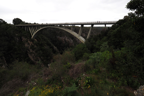
Continuing westward on the N2, past Storms River Gorge, our next stop was Tsitsikamma National Park to see the Grootboom or Big Tree. This massive yellowwood is believed to be around a thousand years old: about the time of the Norman conquest of England.
We spent the entire drive, from Port Elizabeth to Tsitsikamma, listening to Leonard Cohen.
It was November 11, 2016, the day we heard of his passing.
Thea, Hayden, Evan and I were great fans. Leonard’s music was often heard in our house and it played a big part in the soundtrack of our lives.
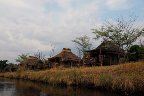
Our accommodation in Tsitsikamma was within the park and yet again we got given the honeymoon chalet.
What is going on?
The bonus wasn’t the king-size bed or the spa but the spectacular views. The accommodation consists of chalets and camp sites, all of them have sea views. However the ‘honeymoon’ chalet had a particularly good position with 180° views of the Indian Ocean crashing into South Africa.
Day 2, November 12: Tsitsikamma National Park to Plettensnerg Bay.
We had planned to do the 3.5 hour Waterfall Walk in Tsitsikamma National Park.
That was cut short by rain.
The rain wasn’t so much the problem, but rather the rocks we had to scramble over to get there, became very slippery.
Tsitsikamma National Park covers about 80 kilometres of coastline and is a popular destination for visitors travelling along the Garden Route.
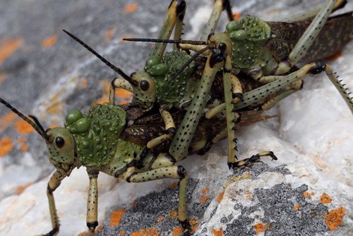
It was spring in South Africa and the wildflowers were in bloom.
We came across three Giant Green African Grasshoppers mating. Another sure sign that spring was in the air.
As the rain came down, I could hear our raincoats laughing at us from the back seat of the car – stupidly we had decided not to take them.
There was nothing left to do but to return to the visitor’s centre and console ourselves with a cup of coffee.
Then the sun came out.
Plan ‘B’ was to go on the Suspension Bridge Walk. This was very crowded but at least there was a boardwalk for the entire journey and no rocks to worry about.
When we returned to the visitor’s centre there was a group of Hyrax playing on the lawn.
They are very comical animals and seem to love life.
Day 3, November 13: Plettenberg Bay.
We were told that very little is open on a Sunday night at Plettenberg Bay, but lunch is always available.
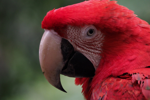
We decided to spend the morning at Birds of Eden free fight sanctuary. This was only a 25 minute drive away, so there would be time to visit before lunch.
It’s the largest single dome, free flight sanctuary in the world, inhabited by African species as well as birds from all over the world.
Many of the birds have been rehabilitated. We even spotted a galah called Rosie who had been rescued – in fact all the parrots in Birds of Eden are ex-pets.
Our lunch was at Equinox, a short walk from Swallow’s Nest, our guest house in Plettenberg Bay.
It was a contemporary restaurant, with great staff and excellent decor.
The food was very good as well.
If you’re a tourist in South Africa, it’s great value for money. We had a four course Sunday lunch for A$15 per head.
The bar prices for wine is also very inexpensive, with the average bottle costing around A$15.
Craft beer is again very reasonable, with a bottle of King’s Blockhouse IPA only costing A$4.
Equinox was right on Plettenberg Bay overlooking a large swell. Late in the afternoon a couple of surfers arrived and attempted to tame the waves. When the surfers left the birds moved in and then the Dolphins.
Day 4, November 14: Plettenberg Bay to Knysna.
Unseasonable wet weather in the Western Cape kept us confined to short trips, or indoors.
It wasn’t a long drive from Plettenberg Bay to Knysna, our next stop. We therefore had time to do a bit of housekeeping.
Thea’s nails were in need of major reconstruction and my hair was looking rather scraggy.
The last cut was in Zanzibar.
I was told that the ‘Cutter’ was due in the salon soon.
A hour and a half later he turned up.
It was a Monday morning and I think he had slept in after a hard Sunday night. That’s if the energy drink he was downing was anything to go by.
This part of the drive would continue on The Garden Route, along the famous Route 62, and then onto Stellenbosch and the Winelands.
‘Coffee culture has come to the Western Cape.’ Well that was the theme in one of the many magazine articles I read while waiting for my haircut.
Knysna is on a narrow bay, fed by the Knysna River and surrounded by hills.
We were in Paradise, literally, as this was the name of the suburb we were staying in.
Before checking into Hamilton Manor, our guest house, we did a short circuit around the area.
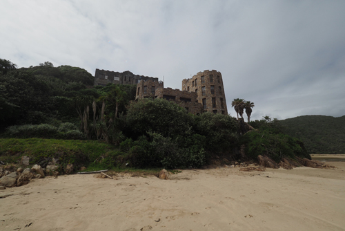
Noetzie Beach in the Pezula Private Estate is a very weird place.
We had to drive for several kilometres, on dirt roads, to get there and our only access was to Noetzie Beach. The rest of the area was enclosed in electrified fences and large gates covered in razor wire.
The reason for the security are the ‘castles’ dotted throughout the the peninsula.
These are stately holiday homes, designed to look like stone castles, using the local rock and complete with turrets.
The strange thing is, that along the stretch of Noetzie Beach we could get to, they were sitting next to fibro-cement beach houses.
Quite a contrast.
Our next diversion was to Knysna Heads, the narrow opening to Knysna Bay.
On one side of the heads is a viewing area and housing while the other side is the Featherbed Private Nature Reserve.
The Southern Cape coastline is truly spectacular, with rugged rocks and a pounding Indian Ocean.
Parking is a strange affair in South Africa.
There are very few parking metres and the locals seem to control who parks where, for how long and at what cost.
There are official parking people or ‘car guards’ and they have a high-vis vest and identification to prove their authenticity.
Then there are the opportunists, who believe that there is money to be made by ‘pretending’ to be a parking official.
They may have a vest, of sorts, and no identification. They appear from nowhere, as soon as you approach a parking spot, and offer to “Watch your car, boss?”
For two reasons we decided to pay most of the people, official or not.
Firstly, in the hope that our car would be looked after and secondly, and more importantly, to give some money to the locals.
The suggested parking fee is somewhere between 20 and 50 cents Australian, so it wasn’t going to break the bank and it’s cheaper than parking metres.
Day 5, November 15: Knysna to Oudtshoorn.
We drove along the N9 and then over the Outeniqua Pass and into Oudtshoorn, the Ostrich capital of the world.
We drove through the pass three times. All the best lookout points are on the right hand side, as you climb up through the pass, heading north from George. They are inaccessible from the left of the road, so we had to double back and then come down. Then of course we had to go through the pass again in order to get to Oudtshoorn.
There were two ostrich feather booms in South Africa, one between 1865 and 1870, the other between 1900 and 1914. The start of WW1 caused of the last boom to collapse. Fashion was the driver behind both booms and the price of the feathers soared. At one point during the first boom the value, per pound, of ostrich feathers equated to that of diamonds.
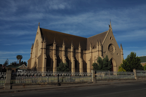
The town was named after Baron Pieter van Oudtshoorn, who became Governor of the Dutch Cape Colony 1772.
The town is full of grand old colonial homes, called ‘feather palaces’ that were built by the wealthy ostrich farmers, known as ‘feather barons’. There are also some magnificent public buildings such as the 1907 CP Nel Museum building and the NG Moedergemeente (Dutch Reformist Church) completed in 1879.
All signs of Oudtshoorn’s past glory.
There are similarities between cities in Australia such as Adelaide, Ballarat and Bendigo with Oudtshoorn. The difference is that Oudtshoorn made is wealth from feathers, not gold.
Parking was a different experience in Oudtshoorn. We arrived in the town just before lunchtime and decided to visit the museum first.
The temperature was on the rise again and there was no one around so we parked our car right out the front.
After touring the museum we walked a short distance to a cafe so Thea could get some lunch and I could get a coffee. When we returned to the car there were a few very dishevelled looking chaps hanging around the vehicles.
They made no attempt to even look like car guards and still expected me to pay for their protection, even though they had just turned up.
This lot went empty handed.
Craft beer, as well as barista coffee, is becoming very popular along the Garden Route.
I discovered Kango, a local craft brewery making a Larger and an IPA. Both are naturally brewed, the IPA was cloudy and both were very drinkable.
We had dinner at a local Italian/African, fusion restaurant.
The food was good, the wines inexpensive and the bill, so low that you wonder how its possible to make and serve a meal for that price.
What we didn’t know was that November was high season and the restaurants were full. We were told by our host to book in advance if we wanted a good one.
At the current prices I’m not surprised that many people are eating out.

Day 6, November 16: Oudtshoorn to Hermanus.
This was going to be the longest drive on our trip.
We left Oudtshoorn at 10am and planned to have a coffee break on the way.
In Barrydale we discovered Diesel and Créme, a very funky cafe and western style bar serving good coffee, craft beer and an interesting menu.
It was in an old motor workshop and decorated with a eclectic selection of memorabilia, much with an automotive theme.
Very fitting being on Route 62.
Our drive to Hermanus took us over the Tradouws Pass on the R324. Again we drove both ways through the pass, as the only vantage points were on the return journey.
Hermanus is the whale centre of the Western cape and everything is geared to whale watching.
We had a drink at Coco, a very pleasant bar overlooking the Hermanus waterfront.
They even had binoculars on the wall, just in case you spotted a Southern Right Whale – we didn’t see any.

Day 7, November 17: Hermanus to Stellenbosch.
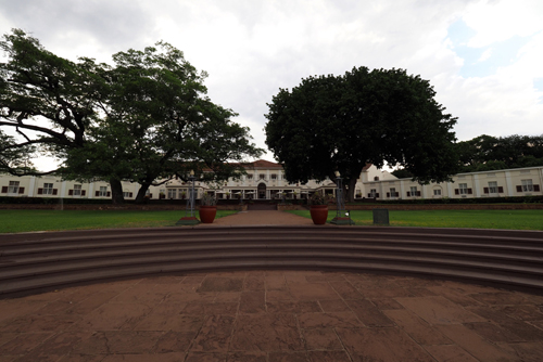
All our accommodation in South Africa, apart from Stormsriver Mouth in the Tsitsikamma National Park, had been in ‘Guest Houses’. These are a fusion between a boutique hotel and a B&B. Many are built in old homes that have undergone extensive renovations to accomodate tourists. We always had an ensuite and the facilities were first class.
They are similar to the ‘Casa Particulares’ in Cuba.
The first recorded guest house was established in 374 AD by St Basil the Great, in Caesarea, (or Kayseri) Cappadocia, Turkey.
There are many benefits of staying in guest houses, such as personalised attention, quietness, lower cost and the food.
A guest house breakfasts was always a good way to start the travelling day.
The Gumtree Lodge in Oudtshoorn, prided themselves on their local produce. At breakfast there was local cheese, cold meats, chutneys and even single origin African coffee. In the evening the owner, Phil Putzel, even ran a little bar serving wine and craft beer, all locally produced.
Running a guest house isn’t without its problems, as we discovered in Hermanus. As we headed to breakfast at the Potting Shed Lodge, we discovered the owner, David, cleaning out the small pond next to the slightly larger swimming pool.
He was looking for a frog.
Apparently its croaking had kept the guests awake for much of the night and they weren’t happy.
On the way to Stellenbosch we made three diversions. The first was to the Harold Porter National Botanical Gardens at Betty’s Bay, then Stony Point to visit the penguins and finally Pringle Bay for coffee.
The botanical gardens is located between the mountains and the sea, with spectacular vistas of both. Then there’s the plants, a stunning array of indigenous flora that was in full bloom, all set in 10 hectares of cultivated gardens. There are about 1,600 plant species in the area, more diverse per unit area than any place on earth. We even discovered a critically endangered Geometric Tortoise wandering across the lawn.
African Penguins were originally called Jackass Penguin, due to their donkey-like braying.
They are the only penguin that breeds in Africa and can grow to a height of between 60 and 70cm. They have a distinctive pink gland above their eyes which is used for thermoregulation in the wildly changing temperatures of the southern oceans.
On the way back to the car park we came across a group of young Hyrax playing in the rocks.
At any age Hyrax are very cute.
At Pringle Bay the cafe offered Red Espresso. The waiter couldn’t explain what it actually was but I decided to have a double shot anyway.
It wasn’t coffee.
It’s made from ground Rooibos tea and then prepared in an espresso machine.
It has no caffeine.
Worth a try, but only once.
Day 8, November 18: Stellenbosch.
In Stellenbosch the Hop-on Hop-off wine bus or Vine Hopper is the best way to visit some of the wineries, taste some wine and not get picked up for drink driving.
When we went to book the Vine Hopper we were told that it was full (remember this was November and the height of the tourist season).
Plan ‘B’ was to drive ourselves.
The company soon put on more buses so it was back to ‘A’ again.
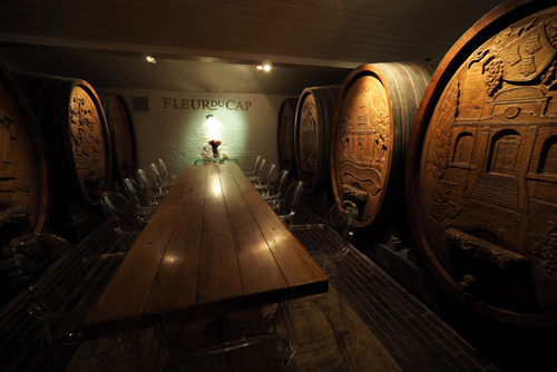
The Vine Hopper offer three routes with seventeen wineries open for visitors. It was Friday and the Friday tour takes in the northern wineries – we visited four of them.
The Stellenbosch wine tours was one of the highlights of our South African adventure.
All the wineries we visited offered a unique experience, not just the wine but the ambience and location as well.
We followed the driver’s advice and had the full wine and cellar tour in Bergkelder, then wine tastings in Beyerskloof and Simonsig, followed by lunch in Delheim.
Like everything else we have come across as tourists in South Africa, generosity and value for money were key.
The tastings were a half serve in a full size wine glass. It was your choice how much you drank.
We soon learnt to pace ourselves.
There was no time limit or pressure to buy at any winery. The cost for five wine tastings averaged A$5 and the Vine Hopper bus was A$60 per person.
The bus gave us plenty of time at each location.
Each of the wineries strived to be individual and their marketing reflected this.
Bergkelder was ‘Following nature’s lead’ while Beyerskloof claimed to be ‘The home of Pinotage’. (Pinotage is a uniquely African variety of grape, being a hybrid of Pinot Noir and Hermitage vine stock). Simonsig, who first produced sparkling wine in South Africa was, ‘The Cuvée experience’ and Delheim, being out of town, was ‘Worth the journey’
Our wine regions in Australia, and possibly others around the world, could benefit from how Stellenbosch market their area.
Like the Yarra Valley and the Mornington Peninsula, Stellenbosch is close to a major city, Cape Town. Yet they offer a unique ‘wine experience’ with restaurants, accommodation and services all catering to the wine lovers.
Most people don’t do a day trip from Cape Town, to visit the wine region, they come and stay for a night or even two.
Apart from wine and tourism Stellenbosch is a university town and therefore has a thriving alternative culture.
After Cape Town, Stellenbosch is the second oldest European settlement in South Africa. It is situated on the Eerste River and is also known as the ‘City of Oaks’ due to the abundance of the trees that were planted by its founder Simon van der Stel in 1679.
Stel named the town after himself and Stellenbosch means ‘(van der) Stel’s Bush’.
The Dutch were excellent hydraulic engineers, which can be seen in Mill Creek, a canal that’s still runs down the main street.
Day 9, November 19: Stellenbosch to Cape Town.
After a bit of gift shopping in Stellenbosch we headed for Cape Town, the final stop in South Africa.
On the way we drove via the other Cape Wineland towns of Franschhoek and Paarl. We then did a brief tour, circling around Table Mountain, before arriving at the Verona Lodge, our guest house in Cape Town.
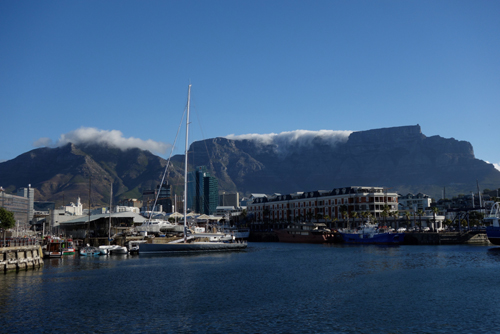
We walked down to the V&A Waterfront, as we did every night, and got our first view of Table Mountain.
This 3 kilometre level plateau overlooks, and dominates, the city of Cape Town. It also seems to be a barometer to the local weather. When the ‘tablecloth’ rolls over the top, the winds are strong and the temperatures are cooler and when the mountain is clear, then so is the weather. The tablecloth is caused by orographic clouds that are created when wind rolls up the the mountain from the south-east and runs into cooler air causing the moisture to condense.
Contrary to science, there is also the legend that the tablecloth is caused by a smoking contest between the Devil and Van Hunks, a local pirate. Van Hunks was a prodigious smoker and the contest has been repeated yearly since the early 1700s.
Breaking dishes will be a constant reminder of African restaurants. It happened at least once a night in the majority of restaurants we visited.
If it’s not the crashing of plates, then it is the clatter of cutlery.
The staff, on the whole, have been fantastic but they do have a total disregard for the hardware.
We were told by one waiter, after we heard yet another crash in the kitchen, that a glass has a lifespan of about one week.
Day 10, November 20: Cape Town.
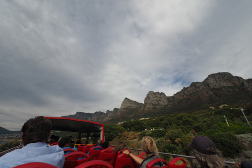
As we do in many cities, we took the Hop-On Hop-Off bus and explored Cape Town. There were four routes covering the city, coast and wine areas.
First we did the city and then the coastal route. The most memorable part of the city route was a drive through District 6. This is an inner suburb of Cape Town that was laid bare during the sixties and seventies. Over 60,000 residents were forcible removed by the apartheid regime in an attempt to stop racial integration.
The place has become a shrine with little development. All that remains now are vacant blocks of land covered in long grass.
After the bus we went walking around Cape Town. This took us past St George’s Cathedral, the Anglican church made famous by Desmond Tutu and his stance against apartheid. The role this church has played in the fight for democracy and the anti apartheid movement has resulted in it now being known as the ‘people’s cathedral’.
Next was the Company Gardens, started by the East India Company in 1652. The gardens were originally planted to provide fresh vegetables to the Dutch trading ships sailing between the Netherlands and the East.
The first wine produced in South Africa came from grapes grown in the garden.
South Africa is a very multi cultural country. Muslims, Malays, Coloureds, Blacks, Whites, Indians and others all form part of the demographic.
But it’s not very equal.
Wherever we travelled there was little sign of a coloured or black middle-class. Admittedly we might have been in the wrong areas but even in the restaurants and bars of the V&A Waterfront there were very few non-whites.
South Africa is also diverse, with a wide variety of cultures, religions, languages and ethnic groups amongst its 52 million people.
According to the 2011 census, Africans make up the majority with 79.2%, Coloured, 8.9%, Whites 8.9%, Indian and Asian, 2.5% and Others, 5%
Cape Town has a population of 3.74 million people with the white folk making up 15.7 %, a lot more than the South African average.
It’s no wonder that there seemed to be a lot more white faces there.
In the afternoon we discovered the South African Jewish Museum in Hatfield Street.
The Jewish story in South Africa is an interesting one.
It makes absolute sense that the Jewish community in South Africa played an important role in the dismantling of the apartheid system.
They know a lot about racial discrimination.
Jewish lawyers were the only whites willing to represent the ANC members charged with crimes against the state.
There was even one lone Jewish voice, in the all white parliament, during the apartheid era. Helen Suzman fought for thirteen years, from 1961 to 1974, to give the Blacks equal rights.
Day 11, November 21: Cape Town.
The departure point to Robben Island, at the V&A Waterfront, is known as the Nelson Mandela Gateway – this sums up the tone of the trip.
In many respects it’s all about Mandela.
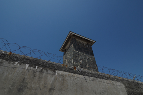
However the history of Robben Island goes back to the end of the 17th century, when the Dutch used the island as a prison for political prisoners.
The island has also been used as a whaling station, leper colony and quarantine station.
During the Second World War it was fortified and became part of Cape Town’s defences.
Due to wide spread pilfering of artefacts by the tourists, you don’t get much freedom to explore Robben Island. After the 45 minute ferry ride from Cape Town you are met on the Robben Island wharf by an armada of buses. From there you are taken around to the various sites, which you view from your seat on the bus before being taken to the main prison complex.
On the bus the commentary was informative and graphic. So much so that a middle aged African American woman, sitting near us, was reduced to tears after hearing the countless stories of atrocities committed on Robben Island.
The guided tour around the main prison area is given by former prisoners and again they painted a very grim picture of life there.
The highlight for most was seeing Nelson Mandela’s cell – this was his home for 18 years from 1964 to 1982.
This is probably the most photographed site on the island.
Day 12, November 22: Cape Town.
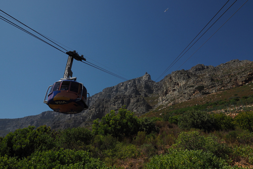
On our final day in Cape Town we planned to go to Table Mountain.
And, as it has been for all our time in the city, luck was with us again.
The tablecloth had cleared, the sun was out and the wind had dropped.
The cable car had only just re-opened, after being closed for over a week due to bad weather.
We booked our tickets online and within an hour we were on the mountain. We even got a rare parking spot metres from the front of the cable car station.
Table Mountain is a constant backdrop to Cape Town. It’s only 1,084 metres high but dominates the city.
The views from the top are stunning.
Our host at the guest house, Sean, suggested that we walk to Maclear’s Beacon on the northern side then take the rim track, on the southern edge, back. It was a great suggestion and we had spectacular views in every direction.
Maclear’s Beacon is a large cairn on the highest point of Table Mountain. It was built in 1865 by the Irish born South African astronomer, Sir Thomas Maclear (1794-1879) to assist in measuring the curvature of the earth.
Our luck continued, as the clouds converged just as we neared the end of our walk.
In the afternoon we drove down to the Cape of Good Hope.
So it seemed, did everyone else.
The placed was packed with bus and car loads of tourist racing to get a snap of themselves in front of the sign post for the Cape.
The Cape of Good Hope is the most south western point in Africa. It’s the spot where ships coming, from Europe, start to travel more eastward than southward.
We then drove to the Cape Point Lighthouse and took the funicular to the top.
The wind was so strong that we had to hold onto the hand rails to stop being blown into the Indian Ocean of even the Atlantic.
We were in Cape Town for four nights and each evening we would walk to the V&A Waterfront for dinner.
It was a pleasant 30 minute walk and there was a huge range of bars and restaurants to choose from.
Getting back to our guest house wasn’t as straight forward, as we had to take a taxi.
There were plenty around but they weren’t allowed to stop and pick-up a fare.
Traffic was controlled by security guards, dressed like real police, they were everywhere.
Actual coppers were nowhere to be seen.
On three occasions we managed to be able to corner a cab, negotiate a price and get in before he was forced to move on.
On our final night guards were again controlling the traffic, this time there were more of them and they had bollards. They were only letting taxis in that were pre booked.
We finally found a rogue driver outside of the control zone and flagged him down.
He explained that the security company and the big taxi groups had joined forces to control the price and keep the independent drivers from working the lucrative tourist areas.
The whole thing smelled of corruption – he wasn’t happy.
He told us that they were charging 100 Rand (A$10) to take the tourists back into the down town area.
This was about a five minute ride.
Our trip with him was about seven minutes and we paid 50 Rand (A$5).
The V&A Waterfront has interesting history, in that the ‘A’ in ‘V&A’ doesn’t stand for Albert, as you might expect. It actually stands for Alfred, the second son of Queen Victoria. In 1860, as a 16 year old Midshipman in the Royal Navy, Prince Alfred visited the the Cape Colony and instantly became a hit with the locals. There is even a plaque on the waterfront commemorating the fact that he tipped the first truck of stone for the new waterfront breakwater.
Day 13, November 23 and 24: Cape Town to Melbourne.
It seemed fitting that on the flight from Cape Town to Dubai I watched the David Yates film, The Legend of Tazan.
It was set in the Congo and nowhere near where we had been, but it was Africa.


, Annecy FR")